
Bob Kerrey Pedestrian Bridge in Omaha
The Bob Kerrey Pedestrian Bridge offers a pleasant and scenic route for walkers and cyclists, spanning across the Missouri River between Omaha, Nebraska, and Council Bluffs, Iowa. As you hike the bridge, you can enjoy panoramic views of both city skylines, the river, and nearby parks, including access to the popular Lewis and Clark Landing. The bridge’s gentle incline and vibrant lighting at night make it both accessible and visually striking, providing an enjoyable experience for outdoor enthusiasts and casual strollers alike. #Hiking #City #River #Nature
- Distance: 1.3 mi
- Elevation gain: 26 m
- Maximum elevation: 305 m
- Elevation loss: 27 m
- Minimum elevation: 294 m
- Moving time: 27 m 43 s
- Moving speed: 2.7 mph
- Maximum speed: 4.2 mph
- Total time: 28 m 16 s
- Global speed: 2.7 mph
Interactive trail map
Trail profile
- Distance: 1.3 mi
- Elevation gain: 26 m
- Maximum elevation: 305 m
- Elevation loss: 27 m
- Minimum elevation: 294 m
- Moving time: 27 m 43 s
- Moving speed: 2.7 mph
- Maximum speed: 4.2 mph
- Total time: 28 m 16 s
- Global speed: 2.7 mph
About this trail
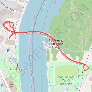
Name: Bob Kerrey Pedestrian Bridge in Omaha trail, distance, elevation, map, profile, GPS track
Coordinates: 41.26299 -95.92492 41.26639 -95.91718
Other hiking, mountain biking, running and outdoor activity trails
Click on a trail to view its statistics, map and profile.
Bellevue Omaha Cycling
United States > Nebraska > Sarpy County > Bellevue
Distance: 28.1 mi • Elevation gain: 266 m • Maximum elevation: 360 m