Import a GPX file

Blessington

Bike loop from Athy. Poulaphouca Reservoir. Wicklow Moutains National Park. #Bike #Loop #Wicklow

  • Distance: 73.9 mi
  • Elevation gain: 957 m
  • Maximum elevation: 266 m
  • Elevation loss: 957 m
  • Minimum elevation: 56 m

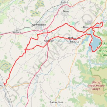
Interactive trail map

Trail profile

  • Distance: 73.9 mi
  • Elevation gain: 957 m
  • Maximum elevation: 266 m
  • Elevation loss: 957 m
  • Minimum elevation: 56 m

About this trail

Other hiking, mountain biking, running and outdoor activity trails

Click on a trail to view its statistics, map and profile.

Blessington

Ireland > County Wicklow

Bike loop from Bray. Poulaphouca Reservoir. Wicklow Mountains National Park. #Bike #Loop #Wicklow

Distance: 50.0 mi • Elevation gain: 1,478 m • Maximum elevation: 497 m

Athy - Durrow

Ireland > County Kildare

#Bike

Distance: 25.5 mi • Elevation gain: 354 m • Maximum elevation: 190 m

Gear up for your next adventure:

🔋Lithium AA Batteries - Long-lasting power that performs well in cold mountain weather
🧺Ultralight Dry Bags - Organize and waterproof your gear inside your rucksack
🦟Anti-Midge & Tick Repellent - Vital for hiking in the Scottish Highlands during summer
🐕Hiking Dog Harnesses - Rugged harnesses for taking your companion on mountain trails
🧤Thermal Touchscreen Gloves - Stay warm while operating your GPS or smartphone camera

As an Amazon Associate, this site earns from qualifying purchases at no extra cost to you.