Thank you for supporting this site ❤️
Make a donation
Make a donation
Gear up for your next adventure:
As an Amazon Associate, this site earns from qualifying purchases at no extra cost to you.
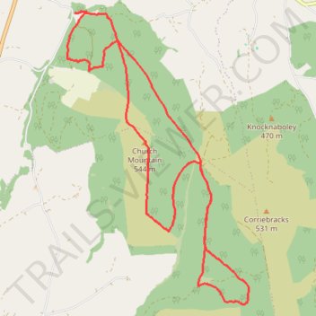
Church Mountain Loop Trail
- Distance: 9.6 mi
- Elevation gain: 569 m
- Maximum elevation: 541 m
- Elevation loss: 569 m
- Minimum elevation: 193 m
- Moving time: 1 h 45 m
- Moving speed: 5.5 mph
- Maximum speed: 9.2 mph
- Total time: 1 h 45 m
- Global speed: 5.5 mph
Interactive trail map
Thank you for supporting this site ❤️
Make a donation
Make a donation
Gear up for your next adventure:
As an Amazon Associate, this site earns from qualifying purchases at no extra cost to you.
Trail profile
- Distance: 9.6 mi
- Elevation gain: 569 m
- Maximum elevation: 541 m
- Elevation loss: 569 m
- Minimum elevation: 193 m
- Moving time: 1 h 45 m
- Moving speed: 5.5 mph
- Maximum speed: 9.2 mph
- Total time: 1 h 45 m
- Global speed: 5.5 mph
Thank you for supporting this site ❤️
Make a donation
Make a donation
Gear up for your next adventure:
As an Amazon Associate, this site earns from qualifying purchases at no extra cost to you.
About this trail
Name: Church Mountain Loop Trail trail, distance, elevation, map, profile, GPS track
Coordinates: 53.03161 -6.60350 53.07173 -6.56211
Thank you for supporting this site ❤️
Make a donation
Make a donation
Gear up for your next adventure:
As an Amazon Associate, this site earns from qualifying purchases at no extra cost to you.
Other hiking, mountain biking, running and outdoor activity trails
Click on a trail to view its statistics, map and profile.