Import a GPX file

Athy - Durrow

#Bike

  • Distance: 25.5 mi
  • Elevation gain: 354 m
  • Maximum elevation: 190 m
  • Elevation loss: 328 m
  • Minimum elevation: 56 m

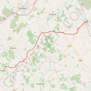
Interactive trail map

Trail profile

  • Distance: 25.5 mi
  • Elevation gain: 354 m
  • Maximum elevation: 190 m
  • Elevation loss: 328 m
  • Minimum elevation: 56 m

About this trail

Other hiking, mountain biking, running and outdoor activity trails

Click on a trail to view its statistics, map and profile.

Blessington

Ireland > County Kildare

Bike loop from Athy. Poulaphouca Reservoir. Wicklow Moutains National Park. #Bike #Loop #Wicklow

Distance: 73.9 mi • Elevation gain: 957 m • Maximum elevation: 266 m

Gear up for your next adventure:

🗺️Ordnance Survey Maps - Essential paper maps for hiking across the UK national parks
📱Phone Mounts for Hiking - Secure mounts to carry your phone on trails
🕶️Polarized Sunglasses - Reduces glare from snow and water when reading terrain
🧤Hiking Gloves - Warm and durable gloves for cold-weather walks
🧥Softshell Jackets - Breathable jackets for active outdoor use

As an Amazon Associate, this site earns from qualifying purchases at no extra cost to you.