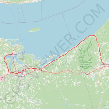
Pictou - Antigonish
Gulf of Saint Lawrence. #Bike #Pictou #Antigonish #SaintLawrence #Atlantic
- Distance: 63.3 mi
- Elevation gain: 808 m
- Maximum elevation: 147 m
- Elevation loss: 820 m
- Minimum elevation: -1 m
Interactive trail map
Trail profile
- Distance: 63.3 mi
- Elevation gain: 808 m
- Maximum elevation: 147 m
- Elevation loss: 820 m
- Minimum elevation: -1 m
About this trail
Name: Pictou - Antigonish trail, distance, elevation, map, profile, GPS track
Coordinates: 45.57092 -62.79803 45.78394 -61.99498
Other hiking, mountain biking, running and outdoor activity trails
Click on a trail to view its statistics, map and profile.
Antigonish - Whycocomagh
Canada > Nova Scotia > Town of Antigonish > Antigonish
Gulf of Saint Lawrence. Cape Breton Island. #Bike #Antigonish #Whycocomagh #SaintLawrence #CapeBreton
Distance: 64.6 mi • Elevation gain: 891 m • Maximum elevation: 135 m
Pictou - Brookfield
Canada > Nova Scotia > Town of Pictou > Pictou
#Bike #Pictou #Brookfield
Distance: 44.4 mi • Elevation gain: 535 m • Maximum elevation: 208 m
Pictou - Antigonish
Canada > Nova Scotia > Town of Pictou > Pictou
#Bike #Pictou #Antigonish
Distance: 46.2 mi • Elevation gain: 744 m • Maximum elevation: 154 m
Trenton Park - Airport Route
Canada > Nova Scotia > Town of Trenton > Town of Trenton
Purple Route
Distance: 2.2 mi • Elevation gain: 37 m • Maximum elevation: 100 m