Make a donation
Gear up for your next adventure:
As an Amazon Associate, this site earns from qualifying purchases at no extra cost to you.
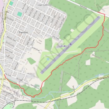
Trenton Park - Airport Route
Purple Route
- Distance: 2.2 mi
- Elevation gain: 37 m
- Maximum elevation: 100 m
- Elevation loss: 94 m
- Minimum elevation: 8 m
- Moving time: 50 m 18 s
- Moving speed: 2.6 mph
- Maximum speed: 3.6 mph
- Total time: 52 m 28 s
- Global speed: 2.5 mph
Interactive trail map
Make a donation
Gear up for your next adventure:
As an Amazon Associate, this site earns from qualifying purchases at no extra cost to you.
Trail profile
- Distance: 2.2 mi
- Elevation gain: 37 m
- Maximum elevation: 100 m
- Elevation loss: 94 m
- Minimum elevation: 8 m
- Moving time: 50 m 18 s
- Moving speed: 2.6 mph
- Maximum speed: 3.6 mph
- Total time: 52 m 28 s
- Global speed: 2.5 mph
Make a donation
Gear up for your next adventure:
As an Amazon Associate, this site earns from qualifying purchases at no extra cost to you.
About this trail
Name: Trenton Park - Airport Route trail, distance, elevation, map, profile, GPS track
Start: Tree-O-Trail, Town of Trenton, Pictou County, Nova Scotia, B0K 1X0, Canada (45.61766 -62.61417)
End: Smelt Brook Trail, Town of Trenton, Pictou County, Nova Scotia, B2H 1Y3, Canada (45.60646 -62.63797)
Coordinates: 45.60246 -62.63797 45.61766 -62.61233
Make a donation
Gear up for your next adventure:
As an Amazon Associate, this site earns from qualifying purchases at no extra cost to you.
Other hiking, mountain biking, running and outdoor activity trails
Click on a trail to view its statistics, map and profile.
Pictou - Antigonish
Canada > Nova Scotia > Town of Pictou > Pictou
Gulf of Saint Lawrence. #Bike #Pictou #Antigonish #SaintLawrence #Atlantic
Distance: 63.3 mi • Elevation gain: 808 m • Maximum elevation: 147 m
Pictou - Antigonish
Canada > Nova Scotia > Town of Pictou > Pictou
#Bike #Pictou #Antigonish
Distance: 46.2 mi • Elevation gain: 744 m • Maximum elevation: 154 m