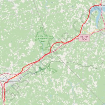
Pictou - Brookfield
#Bike #Pictou #Brookfield
- Distance: 44.4 mi
- Elevation gain: 535 m
- Maximum elevation: 208 m
- Elevation loss: 505 m
- Minimum elevation: -1 m
Interactive trail map
Trail profile
- Distance: 44.4 mi
- Elevation gain: 535 m
- Maximum elevation: 208 m
- Elevation loss: 505 m
- Minimum elevation: -1 m
About this trail
Name: Pictou - Brookfield trail, distance, elevation, map, profile, GPS track
Coordinates: 45.28600 -63.29475 45.68325 -62.72827
Other hiking, mountain biking, running and outdoor activity trails
Click on a trail to view its statistics, map and profile.
Pictou - Antigonish
Canada > Nova Scotia > Town of Pictou > Pictou
Gulf of Saint Lawrence. #Bike #Pictou #Antigonish #SaintLawrence #Atlantic
Distance: 63.3 mi • Elevation gain: 808 m • Maximum elevation: 147 m
Amherst - Brookfield
Canada > Nova Scotia > Municipality of the County of Cumberland > Upper Nappan
Distance: 75.4 mi • Elevation gain: 1,019 m • Maximum elevation: 255 m
Pictou - Antigonish
Canada > Nova Scotia > Town of Pictou > Pictou
#Bike #Pictou #Antigonish
Distance: 46.2 mi • Elevation gain: 744 m • Maximum elevation: 154 m