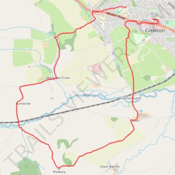
Posbury Hill Loop from Crediton
- Distance: 6.5 mi
- Elevation gain: 245 m
- Maximum elevation: 141 m
- Elevation loss: 283 m
- Minimum elevation: 43 m
- Moving time: 2 h 15 m
- Moving speed: 2.9 mph
- Maximum speed: 16.1 mph
- Total time: 2 h 24 m
- Global speed: 2.7 mph
Interactive trail map
Trail profile
- Distance: 6.5 mi
- Elevation gain: 245 m
- Maximum elevation: 141 m
- Elevation loss: 283 m
- Minimum elevation: 43 m
- Moving time: 2 h 15 m
- Moving speed: 2.9 mph
- Maximum speed: 16.1 mph
- Total time: 2 h 24 m
- Global speed: 2.7 mph
About this trail
Name: Posbury Hill Loop from Crediton trail, distance, elevation, map, profile, GPS track
Coordinates: 50.76639 -3.69573 50.79355 -3.65801
Topography: Mid Devon topographic map, elevation, terrain
Other hiking, mountain biking, running and outdoor activity trails
Click on a trail to view its statistics, map and profile.
Crediton - Newton St Cyres
United Kingdom > England > Devon > Mid Devon > Crediton
Mid devon ride
Distance: 9.0 mi • Elevation gain: 161 m • Maximum elevation: 83 m
Crediton walk
United Kingdom > England > Devon > Mid Devon > Crediton
Mid Devon Walking
Distance: 1.7 mi • Elevation gain: 64 m • Maximum elevation: 114 m