Make a donation
Gear up for your next adventure:
As an Amazon Associate, this site earns from qualifying purchases at no extra cost to you.
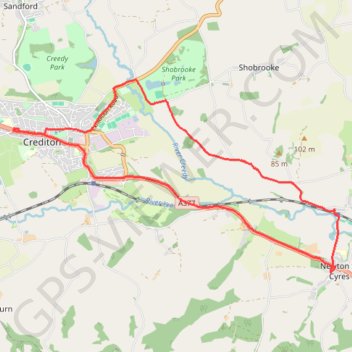
Crediton - Newton St Cyres
Mid devon ride
- Distance: 9.0 mi
- Elevation gain: 161 m
- Maximum elevation: 83 m
- Elevation loss: 160 m
- Minimum elevation: 24 m
- Moving time: 41 m 2 s
- Moving speed: 13.2 mph
- Maximum speed: 29.9 mph
- Total time: 41 m 57 s
- Global speed: 12.9 mph
Interactive trail map
Make a donation
Gear up for your next adventure:
As an Amazon Associate, this site earns from qualifying purchases at no extra cost to you.
Trail profile
- Distance: 9.0 mi
- Elevation gain: 161 m
- Maximum elevation: 83 m
- Elevation loss: 160 m
- Minimum elevation: 24 m
- Moving time: 41 m 2 s
- Moving speed: 13.2 mph
- Maximum speed: 29.9 mph
- Total time: 41 m 57 s
- Global speed: 12.9 mph
Make a donation
Gear up for your next adventure:
As an Amazon Associate, this site earns from qualifying purchases at no extra cost to you.
About this trail
Name: Crediton - Newton St Cyres trail, distance, elevation, map, profile, GPS track
Start: 68, High Street, Crediton, Mid Devon, Devon, England, EX17 3LA, United Kingdom (50.79110 -3.66392)
End: 80, High Street, Crediton, Mid Devon, Devon, England, EX17 3LA, United Kingdom (50.79125 -3.66422)
Coordinates: 50.76992 -3.66574 50.79884 -3.58851
Topography: Mid Devon topographic map, elevation, terrain
Make a donation
Gear up for your next adventure:
As an Amazon Associate, this site earns from qualifying purchases at no extra cost to you.
Other hiking, mountain biking, running and outdoor activity trails
Click on a trail to view its statistics, map and profile.
Posbury Hill Loop from Crediton
United Kingdom > England > Devon > Mid Devon > Crediton
Distance: 6.5 mi • Elevation gain: 245 m • Maximum elevation: 141 m
Crediton Walk
United Kingdom > England > Devon > Mid Devon > Crediton > Fordton
Distance: 3.1 mi • Elevation gain: 104 m • Maximum elevation: 90 m
Crediton walk
United Kingdom > England > Devon > Mid Devon > Crediton
Mid Devon Walking
Distance: 1.7 mi • Elevation gain: 64 m • Maximum elevation: 114 m