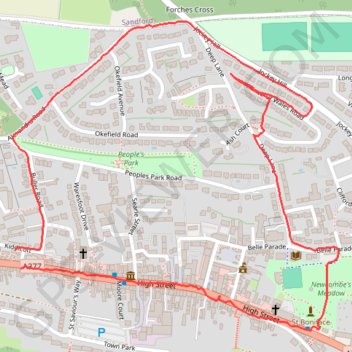
Crediton walk
Mid Devon Walking
- Distance: 1.7 mi
- Elevation gain: 64 m
- Maximum elevation: 114 m
- Elevation loss: 63 m
- Minimum elevation: 61 m
- Moving time: 41 m 4 s
- Moving speed: 2.4 mph
- Maximum speed: 3.4 mph
- Total time: 47 m 32 s
- Global speed: 2.1 mph
Interactive trail map
Trail profile
- Distance: 1.7 mi
- Elevation gain: 64 m
- Maximum elevation: 114 m
- Elevation loss: 63 m
- Minimum elevation: 61 m
- Moving time: 41 m 4 s
- Moving speed: 2.4 mph
- Maximum speed: 3.4 mph
- Total time: 47 m 32 s
- Global speed: 2.1 mph
About this trail
Name: Crediton walk trail, distance, elevation, map, profile, GPS track
Start: 68, High Street, Crediton, Mid Devon, Devon, England, EX17 3LA, United Kingdom (50.79100 -3.66368)
End: Kiddicott, Crediton, Mid Devon, Devon, England, EX17 2AY, United Kingdom (50.79133 -3.66384)
Coordinates: 50.78984 -3.66390 50.79560 -3.65431
Topography: Mid Devon topographic map, elevation, terrain
Other hiking, mountain biking, running and outdoor activity trails
Click on a trail to view its statistics, map and profile.
Crediton - Newton St Cyres
United Kingdom > England > Devon > Mid Devon > Crediton
Mid devon ride
Distance: 9.0 mi • Elevation gain: 161 m • Maximum elevation: 83 m
Posbury Hill Loop from Crediton
United Kingdom > England > Devon > Mid Devon > Crediton
Distance: 6.5 mi • Elevation gain: 245 m • Maximum elevation: 141 m