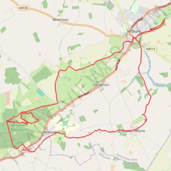
Tetbury Westonbirt Loop
- Distance: 16.3 mi
- Elevation gain: 250 m
- Maximum elevation: 146 m
- Elevation loss: 245 m
- Minimum elevation: 92 m
Interactive trail map
Trail profile
- Distance: 16.3 mi
- Elevation gain: 250 m
- Maximum elevation: 146 m
- Elevation loss: 245 m
- Minimum elevation: 92 m
About this trail
Name: Tetbury Westonbirt Loop trail, distance, elevation, map, profile, GPS track
Coordinates: 51.59722 -2.23095 51.64335 -2.14215
Topography: Cotswold District topographic map, elevation, terrain
Other hiking, mountain biking, running and outdoor activity trails
Click on a trail to view its statistics, map and profile.
Westonbirt Arboretum
United Kingdom > England > Gloucestershire > Cotswold District > Westonbirt
Walk
Distance: 2.9 mi • Elevation gain: 33 m • Maximum elevation: 146 m
Westonbirt Old Arboretum tracks
United Kingdom > England > Gloucestershire > Cotswold District > Westonbirt
Distance: 6.5 mi • Elevation gain: 98 m • Maximum elevation: 146 m
Dean2023-311
United Kingdom > England > Oxfordshire > Oxford
Distance: 192.8 mi • Elevation gain: 3,366 m • Maximum elevation: 290 m
Westonbirt Downs
United Kingdom > England > Gloucestershire > Cotswold District > Westonbirt
Distance: 2.6 mi • Elevation gain: 55 m • Maximum elevation: 146 m
Tetbury
United Kingdom > England > Gloucestershire > Cotswold District > Tetbury
Distance: 9.1 mi • Elevation gain: 165 m • Maximum elevation: 165 m