Westonbirt Old Arboretum tracks
- Distance: 6.5 mi
- Elevation gain: 98 m
- Maximum elevation: 146 m
- Elevation loss: 99 m
- Minimum elevation: 126 m
- Moving time: 2 h 11 m
- Moving speed: 3.0 mph
- Maximum speed: 9.4 mph
- Total time: 2 h 19 m
- Global speed: 2.8 mph
Interactive trail map
Trail profile
- Distance: 6.5 mi
- Elevation gain: 98 m
- Maximum elevation: 146 m
- Elevation loss: 99 m
- Minimum elevation: 126 m
- Moving time: 2 h 11 m
- Moving speed: 3.0 mph
- Maximum speed: 9.4 mph
- Total time: 2 h 19 m
- Global speed: 2.8 mph
About this trail
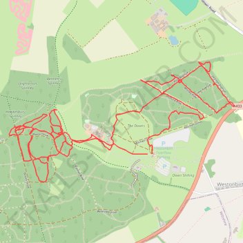
Name: Westonbirt Old Arboretum tracks trail, distance, elevation, map, profile, GPS track
Coordinates: 51.60424 -2.23175 51.61306 -2.20534
Topography: Cotswold District topographic map, elevation, terrain
Other hiking, mountain biking, running and outdoor activity trails
Click on a trail to view its statistics, map and profile.
Westonbirt Arboretum
United Kingdom > England > Gloucestershire > Cotswold District > Westonbirt
Walk
Distance: 2.9 mi • Elevation gain: 33 m • Maximum elevation: 146 m
Tetbury Westonbirt Loop
United Kingdom > England > Gloucestershire > Cotswold District > Tetbury
Distance: 16.3 mi • Elevation gain: 250 m • Maximum elevation: 146 m
Dean2023-311
United Kingdom > England > Oxfordshire > Oxford
Distance: 192.8 mi • Elevation gain: 3,366 m • Maximum elevation: 290 m
Westonbirt Downs
United Kingdom > England > Gloucestershire > Cotswold District > Westonbirt
Distance: 2.6 mi • Elevation gain: 55 m • Maximum elevation: 146 m