Tetbury
- Distance: 9.1 mi
- Elevation gain: 165 m
- Maximum elevation: 165 m
- Elevation loss: 167 m
- Minimum elevation: 102 m
- Moving time: 2 h 46 m
- Moving speed: 3.3 mph
- Maximum speed: 9.4 mph
- Total time: 3 h 12 m
- Global speed: 2.8 mph
Interactive trail map
Trail profile
- Distance: 9.1 mi
- Elevation gain: 165 m
- Maximum elevation: 165 m
- Elevation loss: 167 m
- Minimum elevation: 102 m
- Moving time: 2 h 46 m
- Moving speed: 3.3 mph
- Maximum speed: 9.4 mph
- Total time: 3 h 12 m
- Global speed: 2.8 mph
About this trail
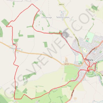
Name: Tetbury trail, distance, elevation, map, profile, GPS track
End: Tetbury, Cotswold District, Gloucestershire, England, GL8 8DQ, United Kingdom (51.63803 -2.15567)
Coordinates: 51.62546 -2.20602 51.65878 -2.15500
Topography: Cotswold District topographic map, elevation, terrain
Other hiking, mountain biking, running and outdoor activity trails
Click on a trail to view its statistics, map and profile.
Tetbury Westonbirt Loop
United Kingdom > England > Gloucestershire > Cotswold District > Tetbury
Distance: 16.3 mi • Elevation gain: 250 m • Maximum elevation: 146 m
Avening loop
United Kingdom > England > Gloucestershire > Nailsworth > Box
Distance: 11.0 mi • Elevation gain: 329 m • Maximum elevation: 186 m
Dean2023-311
United Kingdom > England > Oxfordshire > Oxford
Distance: 192.8 mi • Elevation gain: 3,366 m • Maximum elevation: 290 m