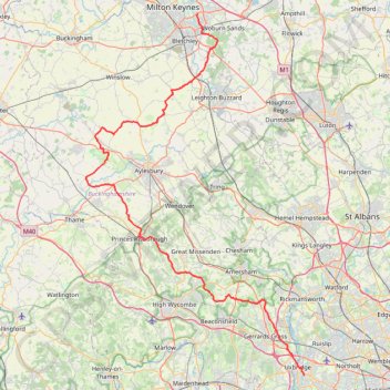
The Jo Cox Way 2022 Day 4 - Milton Keynes to Uxbridge
- Distance: 64.9 mi
- Elevation gain: 1,038 m
- Maximum elevation: 251 m
- Elevation loss: 1,077 m
- Minimum elevation: 32 m
- Moving time: 4 h 54 m
- Moving speed: 13.2 mph
- Maximum speed: 38.5 mph
- Total time: 4 h 54 m
- Global speed: 13.2 mph
Interactive trail map
Trail profile
- Distance: 64.9 mi
- Elevation gain: 1,038 m
- Maximum elevation: 251 m
- Elevation loss: 1,077 m
- Minimum elevation: 32 m
- Moving time: 4 h 54 m
- Moving speed: 13.2 mph
- Maximum speed: 38.5 mph
- Total time: 4 h 54 m
- Global speed: 13.2 mph
About this trail
Name: The Jo Cox Way 2022 Day 4 - Milton Keynes to Uxbridge trail, distance, elevation, map, profile, GPS track
Coordinates: 51.53298 -0.95344 52.02957 -0.46754
Topography: Milton Keynes topographic map, elevation, terrain
Other hiking, mountain biking, running and outdoor activity trails
Click on a trail to view its statistics, map and profile.
The Rye
United Kingdom > England > Buckinghamshire > High Wycombe
Distance: 1.0 mi • Elevation gain: 23 m • Maximum elevation: 78 m
Bike ride Haddenham - Cuddington - Chearsley including The Maltings, Haddenham
United Kingdom > England > Buckinghamshire > Haddenham
Distance: 8.6 mi • Elevation gain: 133 m • Maximum elevation: 126 m
The Jo Cox Way 2022 Day 3 Market Bosworth to Milton Keynes
United Kingdom > England > Leicestershire > Hinckley and Bosworth > Market Bosworth
Distance: 76.4 mi • Elevation gain: 953 m • Maximum elevation: 195 m
Run around Downley, Disraeli and Hughenden
United Kingdom > England > Buckinghamshire > Downley
Wycombe Trail Running
Distance: 6.2 mi • Elevation gain: 208 m • Maximum elevation: 185 m
NW High Wycombe, Downley, Hughenden Park
United Kingdom > England > Buckinghamshire > High Wycombe
Distance: 5.8 mi • Elevation gain: 229 m • Maximum elevation: 171 m
The JCW 23 - Cranfield to Uxbridge
United Kingdom > England > Central Bedfordshire > Cranfield
Distance: 56.0 mi • Elevation gain: 863 m • Maximum elevation: 266 m
Coombe Hill from Wendover
United Kingdom > England > Buckinghamshire > Wendover
Distance: 4.1 mi • Elevation gain: 146 m • Maximum elevation: 261 m
New path at top of Berryfields
United Kingdom > England > Buckinghamshire
Distance: 4.8 mi • Elevation gain: 38 m • Maximum elevation: 84 m
Dockey Woods
United Kingdom > England > Buckinghamshire > Ivinghoe
Distance: 6.0 mi • Elevation gain: 150 m • Maximum elevation: 251 m
Twyford to Hurley loop
United Kingdom > England > Borough of Wokingham > Twyford
Distance: 15.7 mi • Elevation gain: 339 m • Maximum elevation: 143 m
Coombe Hill Loop Trail
United Kingdom > England > Buckinghamshire > Wendover
Distance: 5.7 mi • Elevation gain: 188 m • Maximum elevation: 257 m
Kingsbook loop run
United Kingdom > England > Buckinghamshire > Aylesbury
Afternoon Run
Distance: 6.1 mi • Elevation gain: 36 m • Maximum elevation: 94 m
Ivinghoe Beacon
United Kingdom > England > Buckinghamshire > Dacorum
Distance: 5.1 mi • Elevation gain: 148 m • Maximum elevation: 251 m
JCW25 Day 4
United Kingdom > England > Central Bedfordshire > Cranfield
Distance: 65.8 mi • Elevation gain: 965 m • Maximum elevation: 266 m
Flitwick
United Kingdom > England > Central Bedfordshire > Flitwick
Distance: 10.3 mi • Elevation gain: 142 m • Maximum elevation: 111 m
Route
United Kingdom > England > Central Bedfordshire > Upper Sundon
Distance: 70.2 mi • Elevation gain: 903 m • Maximum elevation: 170 m