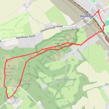
Coombe Hill from Wendover
- Distance: 4.1 mi
- Elevation gain: 146 m
- Maximum elevation: 261 m
- Elevation loss: 144 m
- Minimum elevation: 132 m
- Moving time: 1 h 31 m
- Moving speed: 2.7 mph
- Maximum speed: 4.0 mph
- Total time: 3 h 11 m
- Global speed: 1.3 mph
Interactive trail map
Trail profile
- Distance: 4.1 mi
- Elevation gain: 146 m
- Maximum elevation: 261 m
- Elevation loss: 144 m
- Minimum elevation: 132 m
- Moving time: 1 h 31 m
- Moving speed: 2.7 mph
- Maximum speed: 4.0 mph
- Total time: 3 h 11 m
- Global speed: 1.3 mph
About this trail
Name: Coombe Hill from Wendover trail, distance, elevation, map, profile, GPS track
Start: Witchell, Wendover, Buckinghamshire, England, HP22 6EG, United Kingdom (51.75973 -0.74278)
Coordinates: 51.74595 -0.77239 51.76217 -0.74245
Topography: Buckinghamshire topographic map, elevation, terrain
Other hiking, mountain biking, running and outdoor activity trails
Click on a trail to view its statistics, map and profile.
The Jo Cox Way 2022 Day 4 - Milton Keynes to Uxbridge
United Kingdom > England > City of Milton Keynes > Milton Keynes > Monkston
Distance: 64.9 mi • Elevation gain: 1,038 m • Maximum elevation: 251 m
Coombe Hill Loop Trail
United Kingdom > England > Buckinghamshire > Wendover
Distance: 5.7 mi • Elevation gain: 188 m • Maximum elevation: 257 m