NW High Wycombe, Downley, Hughenden Park
- Distance: 5.8 mi
- Elevation gain: 229 m
- Maximum elevation: 171 m
- Elevation loss: 230 m
- Minimum elevation: 82 m
- Moving time: 1 h 3 m
- Moving speed: 5.5 mph
- Maximum speed: 10.9 mph
- Total time: 1 h 5 m
- Global speed: 5.3 mph
Interactive trail map
Trail profile
- Distance: 5.8 mi
- Elevation gain: 229 m
- Maximum elevation: 171 m
- Elevation loss: 230 m
- Minimum elevation: 82 m
- Moving time: 1 h 3 m
- Moving speed: 5.5 mph
- Maximum speed: 10.9 mph
- Total time: 1 h 5 m
- Global speed: 5.3 mph
About this trail
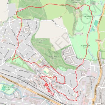
Name: NW High Wycombe, Downley, Hughenden Park trail, distance, elevation, map, profile, GPS track
Coordinates: 51.63471 -0.77516 51.65175 -0.75230
Topography: Buckinghamshire topographic map, elevation, terrain
Other hiking, mountain biking, running and outdoor activity trails
Click on a trail to view its statistics, map and profile.
The Jo Cox Way 2022 Day 4 - Milton Keynes to Uxbridge
United Kingdom > England > City of Milton Keynes > Milton Keynes > Monkston
Distance: 64.9 mi • Elevation gain: 1,038 m • Maximum elevation: 251 m
Run around Downley, Disraeli and Hughenden
United Kingdom > England > Buckinghamshire > Downley
Wycombe Trail Running
Distance: 6.2 mi • Elevation gain: 208 m • Maximum elevation: 185 m