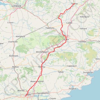
Thurles - Cork
#Bike
- Distance: 80.6 mi
- Elevation gain: 1,137 m
- Maximum elevation: 237 m
- Elevation loss: 1,210 m
- Minimum elevation: 5 m
Interactive trail map
Trail profile
- Distance: 80.6 mi
- Elevation gain: 1,137 m
- Maximum elevation: 237 m
- Elevation loss: 1,210 m
- Minimum elevation: 5 m
About this trail
Name: Thurles - Cork trail, distance, elevation, map, profile, GPS track
Coordinates: 51.88240 -8.50771 52.67929 -7.81119
Other hiking, mountain biking, running and outdoor activity trails
Click on a trail to view its statistics, map and profile.
Lough Curra
Distance: 5.9 mi • Elevation gain: 443 m • Maximum elevation: 577 m
Galtee castle wood Purple
Ireland > County Limerick > The Municipal District of Cappamore — Kilmallock
Distance: 2.6 mi • Elevation gain: 109 m • Maximum elevation: 285 m
Fermoy River Walk
Distance: 2.0 mi • Elevation gain: 20 m • Maximum elevation: 58 m
Annes Grove House Gardens
Distance: 1.8 mi • Elevation gain: 43 m • Maximum elevation: 69 m
Green field park
Distance: 1.9 mi • Elevation gain: 21 m • Maximum elevation: 118 m