Annes Grove House Gardens
- Distance: 1.8 mi
- Elevation gain: 43 m
- Maximum elevation: 69 m
- Elevation loss: 43 m
- Minimum elevation: 48 m
- Moving time: 48 m 12 s
- Moving speed: 2.2 mph
- Maximum speed: 3.4 mph
- Total time: 55 m 37 s
- Global speed: 1.9 mph
Interactive trail map
Trail profile
- Distance: 1.8 mi
- Elevation gain: 43 m
- Maximum elevation: 69 m
- Elevation loss: 43 m
- Minimum elevation: 48 m
- Moving time: 48 m 12 s
- Moving speed: 2.2 mph
- Maximum speed: 3.4 mph
- Total time: 55 m 37 s
- Global speed: 1.9 mph
About this trail
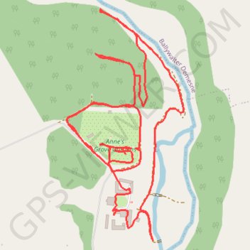
Name: Annes Grove House Gardens trail, distance, elevation, map, profile, GPS track
Coordinates: 52.19406 -8.46755 52.19874 -8.46369
Other hiking, mountain biking, running and outdoor activity trails
Click on a trail to view its statistics, map and profile.
Thurles - Cork
Ireland > County Tipperary > Thurles
#Bike
Distance: 80.6 mi • Elevation gain: 1,137 m • Maximum elevation: 237 m