Import a GPX file

2026-10-29_14-37_Thu

  • Distance: 2.1 mi
  • Elevation gain: 74 m
  • Maximum elevation: 318 m
  • Elevation loss: 68 m
  • Minimum elevation: 278 m
  • Moving time: 44 m 45 s
  • Moving speed: 2.8 mph
  • Maximum speed: 5.4 mph
  • Total time: 44 m 45 s
  • Global speed: 2.8 mph

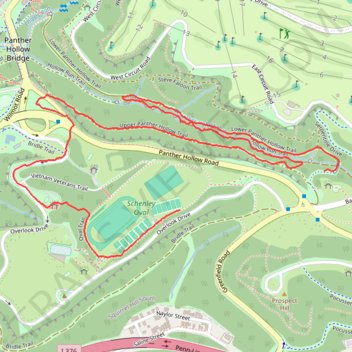
Interactive trail map

Trail profile

  • Distance: 2.1 mi
  • Elevation gain: 74 m
  • Maximum elevation: 318 m
  • Elevation loss: 68 m
  • Minimum elevation: 278 m
  • Moving time: 44 m 45 s
  • Moving speed: 2.8 mph
  • Maximum speed: 5.4 mph
  • Total time: 44 m 45 s
  • Global speed: 2.8 mph

About this trail
Other hiking, mountain biking, running and outdoor activity trails

Click on a trail to view its statistics, map and profile.

Schenley Park and Monongahela River Loop

United States > Pennsylvania > Allegheny County > Pittsburgh

Loop hike through Schenley Park and along Monongahela River. #Hiking #Loop #Nature #City #Park #Forest #River

Distance: 17.5 mi • Elevation gain: 395 m • Maximum elevation: 340 m

Four Rivers and Five Trails Loop

United States > Pennsylvania > Allegheny County > Pittsburgh

Loop hike along Monongahela River. #Hiking #Loop #River #Nature #City

Distance: 38.9 mi • Elevation gain: 687 m • Maximum elevation: 339 m

Gear up for your next adventure:

🎒Hiking Child Carriers - Explore the outdoors with the whole family safely
🧷Tenacious Repair Tape - Instant fix for torn tents, jackets, or dry bags
🧼Biodegradable Soap - Leave-no-trace hygiene for multi-day mountain treks
📐Altimeters & Barometers - Tools for measuring altitude and air pressure
🔥Emergency Fire Starters - Reliable ignition tools for survival situations in damp conditions

As an Amazon Associate, this site earns from qualifying purchases at no extra cost to you.