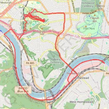
Schenley Park and Monongahela River Loop
Loop hike through Schenley Park and along Monongahela River. #Hiking #Loop #Nature #City #Park #Forest #River
- Distance: 17.5 mi
- Elevation gain: 395 m
- Maximum elevation: 340 m
- Elevation loss: 395 m
- Minimum elevation: 219 m
- Moving time: 4 h 32 m
- Moving speed: 3.9 mph
- Maximum speed: 12.8 mph
- Total time: 4 h 34 m
- Global speed: 3.8 mph
Interactive trail map
Trail profile
- Distance: 17.5 mi
- Elevation gain: 395 m
- Maximum elevation: 340 m
- Elevation loss: 395 m
- Minimum elevation: 219 m
- Moving time: 4 h 32 m
- Moving speed: 3.9 mph
- Maximum speed: 12.8 mph
- Total time: 4 h 34 m
- Global speed: 3.8 mph
About this trail
Name: Schenley Park and Monongahela River Loop trail, distance, elevation, map, profile, GPS track
Coordinates: 40.39477 -79.96238 40.44020 -79.89656
Other hiking, mountain biking, running and outdoor activity trails
Click on a trail to view its statistics, map and profile.