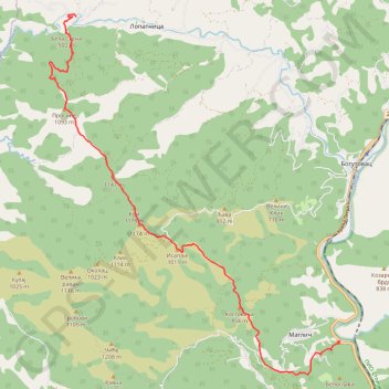
Troglav grebenom od Stance do Maglica
- Distance: 10.2 mi
- Elevation gain: 1,140 m
- Maximum elevation: 1,152 m
- Elevation loss: 1,241 m
- Minimum elevation: 260 m
- Moving time: 6 h 29 m
- Moving speed: 1.6 mph
- Maximum speed: 3.0 mph
- Total time: 8 h 7 m
- Global speed: 1.3 mph
Interactive trail map
Trail profile
- Distance: 10.2 mi
- Elevation gain: 1,140 m
- Maximum elevation: 1,152 m
- Elevation loss: 1,241 m
- Minimum elevation: 260 m
- Moving time: 6 h 29 m
- Moving speed: 1.6 mph
- Maximum speed: 3.0 mph
- Total time: 8 h 7 m
- Global speed: 1.3 mph
About this trail
Name: Troglav grebenom od Stance do Maglica trail, distance, elevation, map, profile, GPS track
Coordinates: 43.60378 20.46042 43.68348 20.54939
Other hiking, mountain biking, running and outdoor activity trails
Click on a trail to view its statistics, map and profile.
2022_Yu
Slovenia > Ajdovščina > Žapuže
Distance: 1,526.9 mi • Elevation gain: 32,048 m • Maximum elevation: 1,950 m
Troglav 3 vrha
Serbia > Central Serbia > Raska Administrative District > Bogutovac
Distance: 10.1 mi • Elevation gain: 1,029 m • Maximum elevation: 1,152 m
Trasa
Serbia > Central Serbia > Raska Administrative District > Bogutovac
Distance: 10.8 mi • Elevation gain: 1,055 m • Maximum elevation: 1,152 m
Stolovi: od Magliča grebenom Lipar, vrh Usovica, povratak gr...
Serbia > Central Serbia > Raska Administrative District > Maglic
Distance: 10.1 mi • Elevation gain: 1,362 m • Maximum elevation: 1,372 m