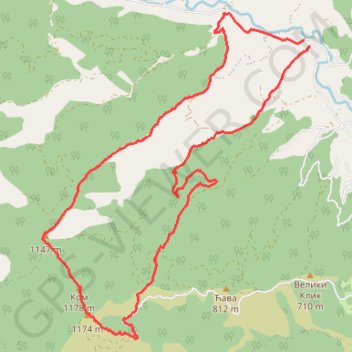
Trasa
- Distance: 10.8 mi
- Elevation gain: 1,055 m
- Maximum elevation: 1,152 m
- Elevation loss: 1,056 m
- Minimum elevation: 285 m
- Moving time: 5 h 39 m
- Moving speed: 1.9 mph
- Maximum speed: 3.8 mph
- Total time: 7 h 23 m
- Global speed: 1.5 mph
Interactive trail map
Trail profile
- Distance: 10.8 mi
- Elevation gain: 1,055 m
- Maximum elevation: 1,152 m
- Elevation loss: 1,056 m
- Minimum elevation: 285 m
- Moving time: 5 h 39 m
- Moving speed: 1.9 mph
- Maximum speed: 3.8 mph
- Total time: 7 h 23 m
- Global speed: 1.5 mph
About this trail
Name: Trasa trail, distance, elevation, map, profile, GPS track
Coordinates: 43.63371 20.47962 43.67808 20.52978
Other hiking, mountain biking, running and outdoor activity trails
Click on a trail to view its statistics, map and profile.
2022_Yu
Slovenia > Ajdovščina > Žapuže
Distance: 1,526.9 mi • Elevation gain: 32,048 m • Maximum elevation: 1,950 m
Troglav 3 vrha
Serbia > Central Serbia > Raska Administrative District > Bogutovac
Distance: 10.1 mi • Elevation gain: 1,029 m • Maximum elevation: 1,152 m
Troglav grebenom od Stance do Maglica
Serbia > Central Serbia > Raska Administrative District > Stanca
Distance: 10.2 mi • Elevation gain: 1,140 m • Maximum elevation: 1,152 m