Import a GPX file

Shoreline trail

Hike / run by the Lake Wyaralong from the dam. #Hiking #Running #Lake #Nature #Forest

  • Distance: 6.1 mi
  • Elevation gain: 265 m
  • Maximum elevation: 158 m
  • Elevation loss: 271 m
  • Minimum elevation: 42 m
  • Moving time: 1 h 21 m
  • Moving speed: 4.5 mph
  • Maximum speed: 7.5 mph
  • Total time: 1 h 30 m
  • Global speed: 4.1 mph

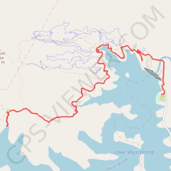
Interactive trail map

Trail profile

  • Distance: 6.1 mi
  • Elevation gain: 265 m
  • Maximum elevation: 158 m
  • Elevation loss: 271 m
  • Minimum elevation: 42 m
  • Moving time: 1 h 21 m
  • Moving speed: 4.5 mph
  • Maximum speed: 7.5 mph
  • Total time: 1 h 30 m
  • Global speed: 4.1 mph

About this trail

Name: Shoreline trail trail, distance, elevation, map, profile, GPS track

Start: Boat Ramp Parking, Service Road, Allenview, Scenic Rim Regional, Queensland, Australia (-27.91261 152.88463)

End: Shoreline Trail, Wyaralong, Scenic Rim Regional, Queensland, Australia (-27.91913 152.84860)

Coordinates: -27.91920 152.84843 -27.90249 152.88512

Other hiking, mountain biking, running and outdoor activity trails

Click on a trail to view its statistics, map and profile.

Mount Joyce

Australia > Queensland

Hike / run to Mount Joyce from the Lake Wyaralong. #Hiking #Running #Lake #Mountain #Forest #Nature

Distance: 5.6 mi • Elevation gain: 427 m • Maximum elevation: 446 m

Gleneagle Kagaru

Australia > Queensland

#MTB #Loop

Distance: 36.8 mi • Elevation gain: 877 m • Maximum elevation: 366 m

Gear up for your next adventure:

🥤Collapsible Water Bottles - Save space in your rucksack as you consume your water
🎒Hiking Backpacks - Comfortable backpacks for day hikes and multi-day treks
🔋Lithium AA Batteries - Long-lasting power that performs well in cold mountain weather
🔋Solar Chargers - Eco-friendly charging solutions for outdoor use
🦶Anti-Blister Balms - Protect your feet before long topographic expeditions

As an Amazon Associate, this site earns from qualifying purchases at no extra cost to you.