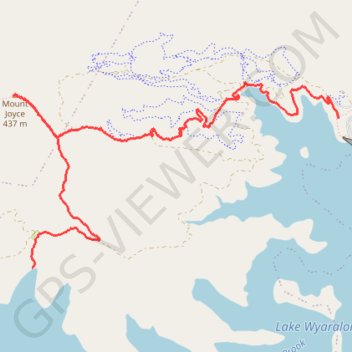
Mount Joyce
Hike / run to Mount Joyce from the Lake Wyaralong. #Hiking #Running #Lake #Mountain #Forest #Nature
- Distance: 5.6 mi
- Elevation gain: 427 m
- Maximum elevation: 446 m
- Elevation loss: 417 m
- Minimum elevation: 68 m
- Moving time: 1 h 35 m
- Moving speed: 3.5 mph
- Maximum speed: 8.0 mph
- Total time: 1 h 41 m
- Global speed: 3.3 mph
Interactive trail map
Trail profile
- Distance: 5.6 mi
- Elevation gain: 427 m
- Maximum elevation: 446 m
- Elevation loss: 417 m
- Minimum elevation: 68 m
- Moving time: 1 h 35 m
- Moving speed: 3.5 mph
- Maximum speed: 8.0 mph
- Total time: 1 h 41 m
- Global speed: 3.3 mph
About this trail
Name: Mount Joyce trail, distance, elevation, map, profile, GPS track
Start: Shoreline Trail, Wyaralong, Scenic Rim Regional, Queensland, Australia (-27.91921 152.84852)
End: Service Road, Wyaralong, Scenic Rim Regional, Queensland, Australia (-27.90565 152.87998)
Coordinates: -27.91921 152.84659 -27.90242 152.87998
Other hiking, mountain biking, running and outdoor activity trails
Click on a trail to view its statistics, map and profile.