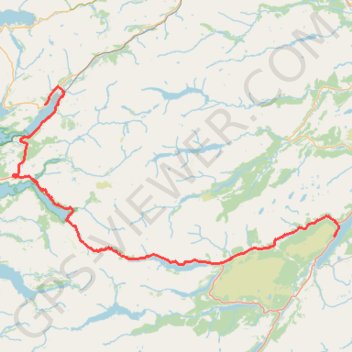
Loch Ness
- Distance: 66.3 mi
- Elevation gain: 1,584 m
- Maximum elevation: 280 m
- Elevation loss: 1,574 m
- Minimum elevation: 0 m
- Moving time: 6 h 44 m
- Moving speed: 9.8 mph
- Maximum speed: 38.9 mph
- Total time: 8 h 59 m
- Global speed: 7.4 mph
Interactive trail map
Trail profile
- Distance: 66.3 mi
- Elevation gain: 1,584 m
- Maximum elevation: 280 m
- Elevation loss: 1,574 m
- Minimum elevation: 0 m
- Moving time: 6 h 44 m
- Moving speed: 9.8 mph
- Maximum speed: 38.9 mph
- Total time: 8 h 59 m
- Global speed: 7.4 mph
About this trail
Name: Loch Ness trail, distance, elevation, map, profile, GPS track
Coordinates: 57.14259 -5.58263 57.43149 -4.60769
Topography: Highland topographic map, elevation, terrain
Other hiking, mountain biking, running and outdoor activity trails
Click on a trail to view its statistics, map and profile.
Munro hillwalk Strathfarrar Rguidhe Gobhar Ghlais Fhuar-thuill
United Kingdom > Scotland > Highland > Cannich
Munro, hillwalk, Strathfarrar, Rguidhe, Gobhar, Ghlais, Fhuar-thuill
Distance: 16.9 mi • Elevation gain: 1,647 m • Maximum elevation: 1,076 m
Munro hillwalk: Ghluasaid, Conbhairean, AChraileag, Fraoch-Choire
United Kingdom > Scotland > Highland
Distance: 17.8 mi • Elevation gain: 2,110 m • Maximum elevation: 1,109 m
Munro hillwalk - Meallan Odhar, The Saddle, Speideam Dhomhuill Bhric, Sgùrr Leac nan Each, Sgùrr na Sgine and Faochag loop
United Kingdom > Scotland > Highland
Distance: 11.8 mi • Elevation gain: 1,648 m • Maximum elevation: 999 m
Great Glen Way (Fort William to Fort Augustus)
United Kingdom > Scotland > Highland > Fort William
Distance: 32.7 mi • Elevation gain: 598 m • Maximum elevation: 108 m
Shiel Bridge to Allt Gleann Gniomhaidh
United Kingdom > Scotland > Highland > Shiel Bridge
Distance: 15.2 mi • Elevation gain: 737 m • Maximum elevation: 349 m
General Wade's Military Road
United Kingdom > Scotland > Highland > Invermoriston
Distance: 53.7 mi • Elevation gain: 1,201 m • Maximum elevation: 392 m