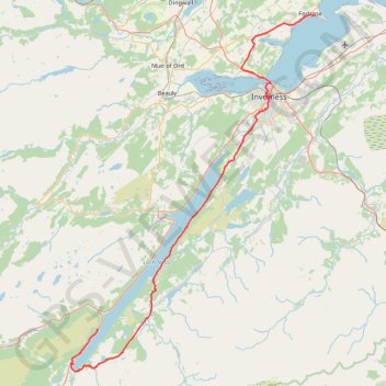
General Wade's Military Road
- Distance: 53.7 mi
- Elevation gain: 1,201 m
- Maximum elevation: 392 m
- Elevation loss: 1,225 m
- Minimum elevation: 0 m
- Moving time: 6 h 33 m
- Moving speed: 8.2 mph
- Maximum speed: 32.6 mph
- Total time: 10 h 2 m
- Global speed: 5.3 mph
Interactive trail map
Trail profile
- Distance: 53.7 mi
- Elevation gain: 1,201 m
- Maximum elevation: 392 m
- Elevation loss: 1,225 m
- Minimum elevation: 0 m
- Moving time: 6 h 33 m
- Moving speed: 8.2 mph
- Maximum speed: 32.6 mph
- Total time: 10 h 2 m
- Global speed: 5.3 mph
About this trail
Name: General Wade's Military Road trail, distance, elevation, map, profile, GPS track
Coordinates: 57.13749 -4.68164 57.58003 -4.11847
Topography: Highland topographic map, elevation, terrain
Other hiking, mountain biking, running and outdoor activity trails
Click on a trail to view its statistics, map and profile.
Great Glen Way (Fort William to Fort Augustus)
United Kingdom > Scotland > Highland > Fort William
Distance: 32.7 mi • Elevation gain: 598 m • Maximum elevation: 108 m
Across Inverness by Bike
United Kingdom > Scotland > Highland > Inverness
Distance: 3.8 mi • Elevation gain: 93 m • Maximum elevation: 89 m
Loch Ness
United Kingdom > Scotland > Highland > Lochcarron
Distance: 66.3 mi • Elevation gain: 1,584 m • Maximum elevation: 280 m