Shiel Bridge to Allt Gleann Gniomhaidh
- Distance: 15.2 mi
- Elevation gain: 737 m
- Maximum elevation: 349 m
- Elevation loss: 481 m
- Minimum elevation: 0 m
- Moving time: 8 h 48 m
- Moving speed: 1.7 mph
- Maximum speed: 4.9 mph
- Total time: 11 h 54 m
- Global speed: 1.3 mph
Interactive trail map
Trail profile
- Distance: 15.2 mi
- Elevation gain: 737 m
- Maximum elevation: 349 m
- Elevation loss: 481 m
- Minimum elevation: 0 m
- Moving time: 8 h 48 m
- Moving speed: 1.7 mph
- Maximum speed: 4.9 mph
- Total time: 11 h 54 m
- Global speed: 1.3 mph
About this trail
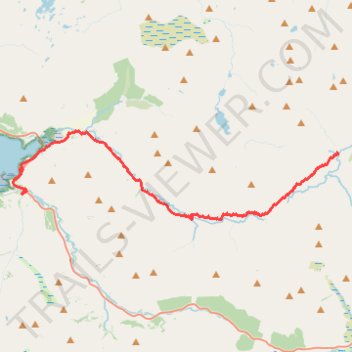
Name: Shiel Bridge to Allt Gleann Gniomhaidh trail, distance, elevation, map, profile, GPS track
End: Highland, Scotland, United Kingdom (57.22700 -5.19550)
Coordinates: 57.20152 -5.42353 57.23513 -5.19505
Topography: Highland topographic map, elevation, terrain
Other hiking, mountain biking, running and outdoor activity trails
Click on a trail to view its statistics, map and profile.
Loch Ness
United Kingdom > Scotland > Highland > Lochcarron
Distance: 66.3 mi • Elevation gain: 1,584 m • Maximum elevation: 280 m