Make a donation
Gear up for your next adventure:
As an Amazon Associate, this site earns from qualifying purchases at no extra cost to you.
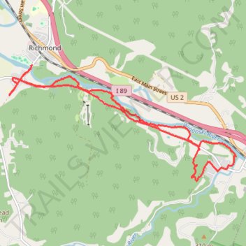
Trails in Richmond along Winooski River
- Distance: 9.3 mi
- Elevation gain: 203 m
- Maximum elevation: 177 m
- Elevation loss: 202 m
- Minimum elevation: 91 m
- Moving time: 1 h 21 m
- Moving speed: 6.8 mph
- Maximum speed: 11.3 mph
- Total time: 1 h 21 m
- Global speed: 6.8 mph
Interactive trail map
Make a donation
Gear up for your next adventure:
As an Amazon Associate, this site earns from qualifying purchases at no extra cost to you.
Trail profile
- Distance: 9.3 mi
- Elevation gain: 203 m
- Maximum elevation: 177 m
- Elevation loss: 202 m
- Minimum elevation: 91 m
- Moving time: 1 h 21 m
- Moving speed: 6.8 mph
- Maximum speed: 11.3 mph
- Total time: 1 h 21 m
- Global speed: 6.8 mph
Make a donation
Gear up for your next adventure:
As an Amazon Associate, this site earns from qualifying purchases at no extra cost to you.
About this trail
Name: Trails in Richmond along Winooski River trail, distance, elevation, map, profile, GPS track
Start: Esplanade Street, Richmond, Chittenden County, Vermont, 05477, United States (44.40184 -72.99666)
Coordinates: 44.37877 -73.00296 44.40184 -72.93997
Make a donation
Gear up for your next adventure:
As an Amazon Associate, this site earns from qualifying purchases at no extra cost to you.
Other hiking, mountain biking, running and outdoor activity trails
Click on a trail to view its statistics, map and profile.
Overocker Trail Richmond
United States > Vermont > Chittenden County > Richmond
Distance: 2.2 mi • Elevation gain: 132 m • Maximum elevation: 224 m
Joy Ride, Richmond
United States > Vermont > Chittenden County > Richmond
Distance: 7.3 mi • Elevation gain: 193 m • Maximum elevation: 293 m