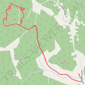
Joy Ride, Richmond
- Distance: 7.3 mi
- Elevation gain: 193 m
- Maximum elevation: 293 m
- Elevation loss: 194 m
- Minimum elevation: 183 m
- Moving time: 1 h 1 m
- Moving speed: 7.1 mph
- Maximum speed: 11.9 mph
- Total time: 1 h 1 m
- Global speed: 7.1 mph
Interactive trail map
Trail profile
- Distance: 7.3 mi
- Elevation gain: 193 m
- Maximum elevation: 293 m
- Elevation loss: 194 m
- Minimum elevation: 183 m
- Moving time: 1 h 1 m
- Moving speed: 7.1 mph
- Maximum speed: 11.9 mph
- Total time: 1 h 1 m
- Global speed: 7.1 mph
About this trail
Name: Joy Ride, Richmond trail, distance, elevation, map, profile, GPS track
Coordinates: 44.36721 -73.03520 44.39257 -72.99964
Other hiking, mountain biking, running and outdoor activity trails
Click on a trail to view its statistics, map and profile.
Cochrans trails
United States > Vermont > Chittenden County > Richmond
Distance: 4.3 mi • Elevation gain: 277 m • Maximum elevation: 387 m
Trails in Richmond along Winooski River
United States > Vermont > Chittenden County > Richmond
Distance: 9.3 mi • Elevation gain: 203 m • Maximum elevation: 177 m