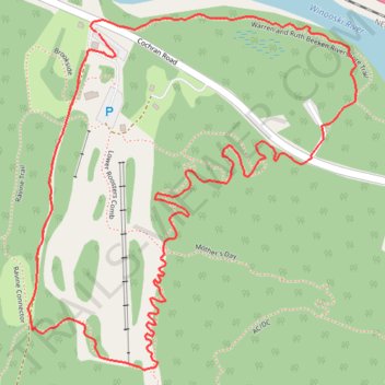
Overocker Trail Richmond
- Distance: 2.2 mi
- Elevation gain: 132 m
- Maximum elevation: 224 m
- Elevation loss: 132 m
- Minimum elevation: 92 m
- Moving time: 49 m 15 s
- Moving speed: 2.7 mph
- Maximum speed: 4.0 mph
- Total time: 49 m 15 s
- Global speed: 2.7 mph
Interactive trail map
Trail profile
- Distance: 2.2 mi
- Elevation gain: 132 m
- Maximum elevation: 224 m
- Elevation loss: 132 m
- Minimum elevation: 92 m
- Moving time: 49 m 15 s
- Moving speed: 2.7 mph
- Maximum speed: 4.0 mph
- Total time: 49 m 15 s
- Global speed: 2.7 mph
About this trail
Name: Overocker Trail Richmond trail, distance, elevation, map, profile, GPS track
Coordinates: 44.38974 -72.98385 44.39684 -72.97468
Other hiking, mountain biking, running and outdoor activity trails
Click on a trail to view its statistics, map and profile.
Trails in Richmond along Winooski River
United States > Vermont > Chittenden County > Richmond
Distance: 9.3 mi • Elevation gain: 203 m • Maximum elevation: 177 m