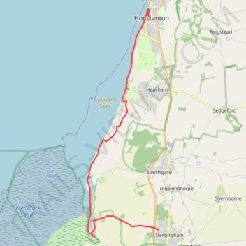
Norfolk Coast Path - Dersingham to Hunstanton
- Distance: 11.4 mi
- Elevation gain: 59 m
- Maximum elevation: 24 m
- Elevation loss: 46 m
- Minimum elevation: -2 m
- Moving time: 3 h 52 m
- Moving speed: 2.9 mph
- Maximum speed: 4.7 mph
- Total time: 4 h 22 m
- Global speed: 2.6 mph
Interactive trail map
Trail profile
- Distance: 11.4 mi
- Elevation gain: 59 m
- Maximum elevation: 24 m
- Elevation loss: 46 m
- Minimum elevation: -2 m
- Moving time: 3 h 52 m
- Moving speed: 2.9 mph
- Maximum speed: 4.7 mph
- Total time: 4 h 22 m
- Global speed: 2.6 mph
About this trail
Name: Norfolk Coast Path - Dersingham to Hunstanton trail, distance, elevation, map, profile, GPS track
Coordinates: 52.84531 0.44421 52.94324 0.49558
Topography: King's Lynn and West Norfolk topographic map, elevation, terrain
Other hiking, mountain biking, running and outdoor activity trails
Click on a trail to view its statistics, map and profile.
Norfolk Coast Path - King's Lynn to Dersingham
United Kingdom > England > Norfolk > King's Lynn and West Norfolk > King's Lynn
Distance: 13.1 mi • Elevation gain: 54 m • Maximum elevation: 14 m
Hunstanton to Kings Lynn
United Kingdom > England > Norfolk > King's Lynn and West Norfolk > Hunstanton
Norfolk Coast Path/England Coast Path
Distance: 19.4 mi • Elevation gain: 90 m • Maximum elevation: 25 m