Make a donation
Gear up for your next adventure:
As an Amazon Associate, this site earns from qualifying purchases at no extra cost to you.
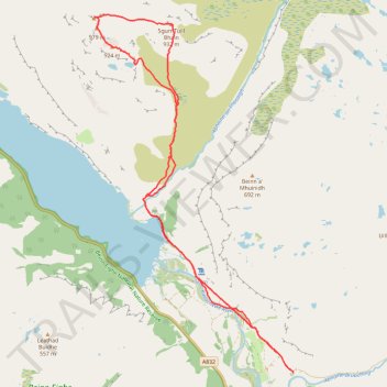
Tracked with OSMTracker for Android™
- Distance: 12.3 mi
- Elevation gain: 1,096 m
- Maximum elevation: 973 m
- Elevation loss: 1,096 m
- Minimum elevation: 12 m
- Moving time: 7 h 18 m
- Moving speed: 1.7 mph
- Maximum speed: 3.7 mph
- Total time: 8 h 21 m
- Global speed: 1.5 mph
Interactive trail map
Make a donation
Gear up for your next adventure:
As an Amazon Associate, this site earns from qualifying purchases at no extra cost to you.
Trail profile
- Distance: 12.3 mi
- Elevation gain: 1,096 m
- Maximum elevation: 973 m
- Elevation loss: 1,096 m
- Minimum elevation: 12 m
- Moving time: 7 h 18 m
- Moving speed: 1.7 mph
- Maximum speed: 3.7 mph
- Total time: 8 h 21 m
- Global speed: 1.5 mph
Make a donation
Gear up for your next adventure:
As an Amazon Associate, this site earns from qualifying purchases at no extra cost to you.
About this trail
Name: Tracked with OSMTracker for Android™ trail, distance, elevation, map, profile, GPS track
Start: A832, Incheril, Kinlochewe, Highland, Scotland, IV22 2PA, United Kingdom (57.60873 -5.28618)
End: A832, Incheril, Kinlochewe, Highland, Scotland, IV22 2PA, United Kingdom (57.60877 -5.28620)
Coordinates: 57.60873 -5.34728 57.66759 -5.28607
Topography: Highland topographic map, elevation, terrain
Make a donation
Gear up for your next adventure:
As an Amazon Associate, this site earns from qualifying purchases at no extra cost to you.
Other hiking, mountain biking, running and outdoor activity trails
Click on a trail to view its statistics, map and profile.
Walk up into Beinn Eighe National Nature Reserve
United Kingdom > Scotland > Highland > Kinlochewe > Taagan
Distance: 4.3 mi • Elevation gain: 354 m • Maximum elevation: 372 m
Walk up Slioch
United Kingdom > Scotland > Highland
Distance: 3.7 mi • Elevation gain: 470 m • Maximum elevation: 972 m