Make a donation
Gear up for your next adventure:
As an Amazon Associate, this site earns from qualifying purchases at no extra cost to you.
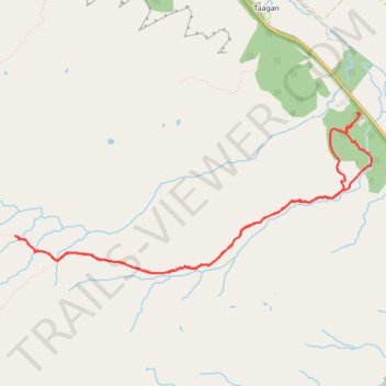
Walk up into Beinn Eighe National Nature Reserve
- Distance: 4.3 mi
- Elevation gain: 354 m
- Maximum elevation: 372 m
- Elevation loss: 354 m
- Minimum elevation: 25 m
- Moving time: 2 h 17 m
- Moving speed: 1.9 mph
- Maximum speed: 3.7 mph
- Total time: 2 h 56 m
- Global speed: 1.5 mph
Interactive trail map
Make a donation
Gear up for your next adventure:
As an Amazon Associate, this site earns from qualifying purchases at no extra cost to you.
Trail profile
- Distance: 4.3 mi
- Elevation gain: 354 m
- Maximum elevation: 372 m
- Elevation loss: 354 m
- Minimum elevation: 25 m
- Moving time: 2 h 17 m
- Moving speed: 1.9 mph
- Maximum speed: 3.7 mph
- Total time: 2 h 56 m
- Global speed: 1.5 mph
Make a donation
Gear up for your next adventure:
As an Amazon Associate, this site earns from qualifying purchases at no extra cost to you.
About this trail
Name: Walk up into Beinn Eighe National Nature Reserve trail, distance, elevation, map, profile, GPS track
Start: A832, Taagan, Kinlochewe, Highland, Scotland, IV22 2PD, United Kingdom (57.61279 -5.31814)
End: A832, Taagan, Kinlochewe, Highland, Scotland, IV22 2PD, United Kingdom (57.61342 -5.31740)
Coordinates: 57.60370 -5.35667 57.61358 -5.31586
Topography: Highland topographic map, elevation, terrain
Make a donation
Gear up for your next adventure:
As an Amazon Associate, this site earns from qualifying purchases at no extra cost to you.
Other hiking, mountain biking, running and outdoor activity trails
Click on a trail to view its statistics, map and profile.
Munro Hillwalk - Slioch and Sgurr Tuill Bhain loop
United Kingdom > Scotland > Highland > Kinlochewe > Incheril
Distance: 12.3 mi • Elevation gain: 1,096 m • Maximum elevation: 973 m