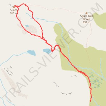
Walk up Slioch
- Distance: 3.7 mi
- Elevation gain: 470 m
- Maximum elevation: 972 m
- Elevation loss: 558 m
- Minimum elevation: 427 m
- Moving time: 1 h 59 m
- Moving speed: 1.9 mph
- Maximum speed: 4.5 mph
- Total time: 2 h 30 m
- Global speed: 1.5 mph
Interactive trail map
Trail profile
- Distance: 3.7 mi
- Elevation gain: 470 m
- Maximum elevation: 972 m
- Elevation loss: 558 m
- Minimum elevation: 427 m
- Moving time: 1 h 59 m
- Moving speed: 1.9 mph
- Maximum speed: 4.5 mph
- Total time: 2 h 30 m
- Global speed: 1.5 mph
About this trail
Name: Walk up Slioch trail, distance, elevation, map, profile, GPS track
Start: Coire an Tuill Bhain, Highland, Scotland, United Kingdom (57.65328 -5.32220)
End: Coire an Tuill Bhain, Highland, Scotland, United Kingdom (57.65045 -5.32241)
Coordinates: 57.65045 -5.34707 57.66755 -5.32187
Topography: Highland topographic map, elevation, terrain
Other hiking, mountain biking, running and outdoor activity trails
Click on a trail to view its statistics, map and profile.
Munro Hillwalk - Slioch and Sgurr Tuill Bhain loop
United Kingdom > Scotland > Highland > Kinlochewe > Incheril
Distance: 12.3 mi • Elevation gain: 1,096 m • Maximum elevation: 973 m