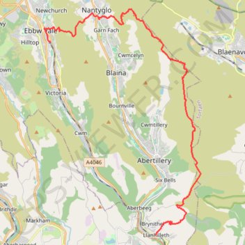
Ebbw Dale to Llanhilleth via Mulfran, Twyn Carn-Canddo, Cefn-Coch and Coity Mountain
- Distance: 13.7 mi
- Elevation gain: 581 m
- Maximum elevation: 574 m
- Elevation loss: 712 m
- Minimum elevation: 142 m
- Moving time: 5 h 28 m
- Moving speed: 2.5 mph
- Maximum speed: 10.9 mph
- Total time: 5 h 54 m
- Global speed: 2.3 mph
Interactive trail map
Trail profile
- Distance: 13.7 mi
- Elevation gain: 581 m
- Maximum elevation: 574 m
- Elevation loss: 712 m
- Minimum elevation: 142 m
- Moving time: 5 h 28 m
- Moving speed: 2.5 mph
- Maximum speed: 10.9 mph
- Total time: 5 h 54 m
- Global speed: 2.3 mph
About this trail
Name: Ebbw Dale to Llanhilleth via Mulfran, Twyn Carn-Canddo, Cefn-Coch and Coity Mountain trail, distance, elevation, map, profile, GPS track
End: 2, Meadow Street, Llanhilleth, Blaenau Gwent, Wales, NP13 2HT, United Kingdom (51.70011 -3.13459)
Coordinates: 51.70010 -3.20624 51.78970 -3.10615
Topography: Blaenau Gwent topographic map, elevation, terrain
Other hiking, mountain biking, running and outdoor activity trails
Click on a trail to view its statistics, map and profile.
Silent Valley Nature Reserve loop trail
United Kingdom > Wales > Blaenau Gwent > Cwm
Distance: 1.5 mi • Elevation gain: 97 m • Maximum elevation: 356 m
The Headstock 500
United Kingdom > Wales > Newport > Newport
Distance: 300.4 mi • Elevation gain: 9,616 m • Maximum elevation: 691 m
Trevor Rowson Park Loop
United Kingdom > Wales > Blaenau Gwent > Nantyglo > Coalbrookvale
Distance: 1.4 mi • Elevation gain: 28 m • Maximum elevation: 327 m