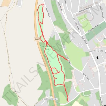
Trevor Rowson Park Loop
- Distance: 1.4 mi
- Elevation gain: 28 m
- Maximum elevation: 327 m
- Elevation loss: 28 m
- Minimum elevation: 308 m
- Moving time: 33 m 7 s
- Moving speed: 2.6 mph
- Maximum speed: 5.5 mph
- Total time: 33 m 43 s
- Global speed: 2.5 mph
Interactive trail map
Trail profile
- Distance: 1.4 mi
- Elevation gain: 28 m
- Maximum elevation: 327 m
- Elevation loss: 28 m
- Minimum elevation: 308 m
- Moving time: 33 m 7 s
- Moving speed: 2.6 mph
- Maximum speed: 5.5 mph
- Total time: 33 m 43 s
- Global speed: 2.5 mph
About this trail
Name: Trevor Rowson Park Loop trail, distance, elevation, map, profile, GPS track
Coordinates: 51.77799 -3.17287 51.78463 -3.16949
Topography: Blaenau Gwent topographic map, elevation, terrain
Other hiking, mountain biking, running and outdoor activity trails
Click on a trail to view its statistics, map and profile.
The Headstock 500
United Kingdom > Wales > Newport > Newport
Distance: 300.4 mi • Elevation gain: 9,616 m • Maximum elevation: 691 m
Ebbw Dale to Llanhilleth via Mulfran, Twyn Carn-Canddo, Cefn-Coch and Coity Mountain
United Kingdom > Wales > Blaenau Gwent > Ebbw Vale
Distance: 13.7 mi • Elevation gain: 581 m • Maximum elevation: 574 m