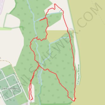
Silent Valley Nature Reserve loop trail
- Distance: 1.5 mi
- Elevation gain: 97 m
- Maximum elevation: 356 m
- Elevation loss: 100 m
- Minimum elevation: 266 m
- Moving time: 42 m 25 s
- Moving speed: 2.2 mph
- Maximum speed: 4.1 mph
- Total time: 43 m 27 s
- Global speed: 2.1 mph
Interactive trail map
Trail profile
- Distance: 1.5 mi
- Elevation gain: 97 m
- Maximum elevation: 356 m
- Elevation loss: 100 m
- Minimum elevation: 266 m
- Moving time: 42 m 25 s
- Moving speed: 2.2 mph
- Maximum speed: 4.1 mph
- Total time: 43 m 27 s
- Global speed: 2.1 mph
About this trail
Name: Silent Valley Nature Reserve loop trail trail, distance, elevation, map, profile, GPS track
Start: Cendl Terrace, Victoria, Cwm, Blaenau Gwent, Wales, NP23 7RX, United Kingdom (51.74654 -3.17951)
End: Cendl Terrace, Victoria, Cwm, Blaenau Gwent, Wales, NP23 7RX, United Kingdom (51.74658 -3.17917)
Coordinates: 51.74645 -3.17955 51.75247 -3.17485
Topography: Blaenau Gwent topographic map, elevation, terrain
Other hiking, mountain biking, running and outdoor activity trails
Click on a trail to view its statistics, map and profile.
The Headstock 500
United Kingdom > Wales > Newport > Newport
Distance: 300.4 mi • Elevation gain: 9,616 m • Maximum elevation: 691 m
Ebbw Dale to Llanhilleth via Mulfran, Twyn Carn-Canddo, Cefn-Coch and Coity Mountain
United Kingdom > Wales > Blaenau Gwent > Ebbw Vale
Distance: 13.7 mi • Elevation gain: 581 m • Maximum elevation: 574 m