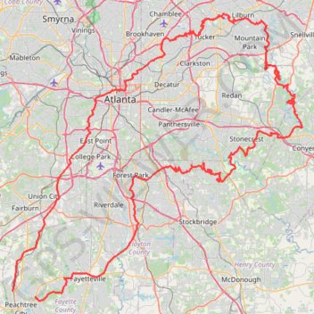
Atlanta, Lilburn, Yellow River Park, Panola, Jonesboro
- Distance: 208.1 mi
- Elevation gain: 4,058 m
- Maximum elevation: 338 m
- Elevation loss: 4,050 m
- Minimum elevation: 210 m
- Moving time: 16 h 21 m
- Moving speed: 12.7 mph
- Maximum speed: 36.6 mph
- Total time: 17 h 36 m
- Global speed: 11.8 mph
Interactive trail map
Trail profile
- Distance: 208.1 mi
- Elevation gain: 4,058 m
- Maximum elevation: 338 m
- Elevation loss: 4,050 m
- Minimum elevation: 210 m
- Moving time: 16 h 21 m
- Moving speed: 12.7 mph
- Maximum speed: 36.6 mph
- Total time: 17 h 36 m
- Global speed: 11.8 mph
About this trail
Name: Atlanta, Lilburn, Yellow River Park, Panola, Jonesboro trail, distance, elevation, map, profile, GPS track
Coordinates: 33.41060 -84.60712 33.89226 -84.02246
Other hiking, mountain biking, running and outdoor activity trails
Click on a trail to view its statistics, map and profile.
East Palisades and Bamboo Forest Loop
United States > Georgia > Fulton County > Atlanta
Starting from the Whitewater Creek side of the East Palisades unit, this loop follows the wooded bank of the Chattahoochee River upstream, passing rocky river edges, small islands, and open views across the water. At the northern end of the route, the path reaches the Bamboo Forest, a distinctive riverside…
Distance: 4.4 mi • Elevation gain: 203 m • Maximum elevation: 310 m
Bamboo Forest via East Palisades Loop in Chattahoochee River National Recreation Area
United States > Georgia > Fulton County > Atlanta
The Bamboo Forest via East Palisades Loop offers a unique hiking experience that brings you close to nature while being conveniently located near Atlanta. Hikers can enjoy views of the Chattahoochee River, traverse through a small but enchanting bamboo forest, and explore sections with striking rock…
Distance: 4.1 mi • Elevation gain: 188 m • Maximum elevation: 310 m
Ride from Smyrna to Marietta on the Mountain to River Trail
United States > Georgia > Cobb County > Smyrna
Distance: 13.6 mi • Elevation gain: 129 m • Maximum elevation: 352 m
East Palisades and Bamboo Forest Loop Trail
United States > Georgia > Fulton County > Atlanta
The East Palisades and Bamboo Forest Loop Trail in the Chattahoochee River National Recreation Area offers hikers a scenic journey through diverse landscapes. As you traverse the trail, you'll encounter the towering bamboo forest—a unique and unexpected feature in Georgia—that creates a serene atmosphere…
Distance: 4.4 mi • Elevation gain: 205 m • Maximum elevation: 310 m
Bike ride to bus stop to go into town, then circle back along the silver comet trail and ride the newly paved part of the beltline connector
United States > Georgia > Cobb County > Smyrna
Distance: 14.9 mi • Elevation gain: 273 m • Maximum elevation: 333 m
Walk around Lenox Park
United States > Georgia > DeKalb County > Brookhaven
Distance: 1.4 mi • Elevation gain: 40 m • Maximum elevation: 291 m
More bike ride on the Silver Comet Trail (and some other side quests)
United States > Georgia > Polk County
Distance: 47.8 mi • Elevation gain: 854 m • Maximum elevation: 350 m
Bike ride down the Silver Comet Trail (and some side quests)
United States > Georgia > Cobb County > Smyrna
Distance: 82.1 mi • Elevation gain: 1,304 m • Maximum elevation: 351 m
Powder Springs, Allatoona trails, Dallas, Chatt Hills
United States > Georgia > Fayette County > Tyrone > Stop
Distance: 198.6 mi • Elevation gain: 3,805 m • Maximum elevation: 379 m
A Better Cobb Group Ride - Mountain to River Trail
United States > Georgia > Cobb County > Smyrna
Distance: 18.4 mi • Elevation gain: 220 m • Maximum elevation: 353 m
Bicycle ride around Smyrna, mostly on bike trails
United States > Georgia > Cobb County > Smyrna
Distance: 10.3 mi • Elevation gain: 233 m • Maximum elevation: 333 m
Morrow, Forest Park, Atlanta, Fairburn
United States > Georgia > Fayette County > Peachtree City
Distance: 115.6 mi • Elevation gain: 1,824 m • Maximum elevation: 325 m
Atlanta Critical Mass (partial)
United States > Georgia > Fulton County > Atlanta
Distance: 12.3 mi • Elevation gain: 263 m • Maximum elevation: 360 m
Atlanta Critical Mass bike ride
United States > Georgia > Fulton County > Atlanta
Distance: 8.8 mi • Elevation gain: 207 m • Maximum elevation: 361 m
The Atlanta Donut Ride
United States > Georgia > Fulton County > Atlanta
Distance: 10.2 mi • Elevation gain: 237 m • Maximum elevation: 352 m
Atlanta Critical Mass
United States > Georgia > Fulton County > Atlanta
Distance: 14.5 mi • Elevation gain: 334 m • Maximum elevation: 342 m