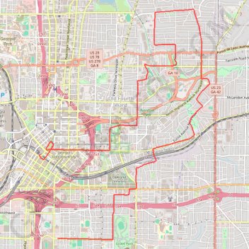
The Atlanta Donut Ride
- Distance: 10.2 mi
- Elevation gain: 237 m
- Maximum elevation: 352 m
- Elevation loss: 204 m
- Minimum elevation: 273 m
- Moving time: 1 h 15 m
- Moving speed: 8.1 mph
- Maximum speed: 18.8 mph
- Total time: 2 h 49 m
- Global speed: 3.6 mph
Interactive trail map
Trail profile
- Distance: 10.2 mi
- Elevation gain: 237 m
- Maximum elevation: 352 m
- Elevation loss: 204 m
- Minimum elevation: 273 m
- Moving time: 1 h 15 m
- Moving speed: 8.1 mph
- Maximum speed: 18.8 mph
- Total time: 2 h 49 m
- Global speed: 3.6 mph
About this trail
Name: The Atlanta Donut Ride trail, distance, elevation, map, profile, GPS track
Coordinates: 33.73661 -84.39126 33.78243 -84.35048
Other hiking, mountain biking, running and outdoor activity trails
Click on a trail to view its statistics, map and profile.
Atlanta, Lilburn, Yellow River Park, Panola, Jonesboro
United States > Georgia > Fayette County > Peachtree City > Stop
Distance: 208.1 mi • Elevation gain: 4,058 m • Maximum elevation: 338 m
Atlanta Critical Mass (partial)
United States > Georgia > Fulton County > Atlanta
Distance: 12.3 mi • Elevation gain: 263 m • Maximum elevation: 360 m
Atlanta Critical Mass bike ride
United States > Georgia > Fulton County > Atlanta
Distance: 8.8 mi • Elevation gain: 207 m • Maximum elevation: 361 m
Atlanta Critical Mass
United States > Georgia > Fulton County > Atlanta
Distance: 14.5 mi • Elevation gain: 334 m • Maximum elevation: 342 m