Bike ride down the Silver Comet Trail (and some side quests)
- Distance: 82.1 mi
- Elevation gain: 1,304 m
- Maximum elevation: 351 m
- Elevation loss: 1,327 m
- Minimum elevation: 224 m
- Moving time: 8 h 7 m
- Moving speed: 10.1 mph
- Maximum speed: 33.4 mph
- Total time: 10 h 13 m
- Global speed: 8.0 mph
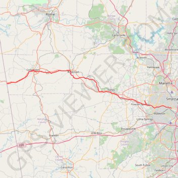
Interactive trail map
Trail profile
- Distance: 82.1 mi
- Elevation gain: 1,304 m
- Maximum elevation: 351 m
- Elevation loss: 1,327 m
- Minimum elevation: 224 m
- Moving time: 8 h 7 m
- Moving speed: 10.1 mph
- Maximum speed: 33.4 mph
- Total time: 10 h 13 m
- Global speed: 8.0 mph
About this trail
Name: Bike ride down the Silver Comet Trail (and some side quests) trail, distance, elevation, map, profile, GPS track
Start: Silver Comet Trail, Smyrna, Cobb County, Georgia, 30082, United States (33.84191 -84.51782)
Coordinates: 33.84175 -85.39604 34.01183 -84.51780
Other hiking, mountain biking, running and outdoor activity trails
Click on a trail to view its statistics, map and profile.
Ride from Smyrna to Marietta on the Mountain to River Trail
United States > Georgia > Cobb County > Smyrna
Distance: 13.6 mi • Elevation gain: 129 m • Maximum elevation: 352 m
Bike ride to bus stop to go into town, then circle back along the silver comet trail and ride the newly paved part of the beltline connector
United States > Georgia > Cobb County > Smyrna
Distance: 14.9 mi • Elevation gain: 273 m • Maximum elevation: 333 m
More bike ride on the Silver Comet Trail (and some other side quests)
United States > Georgia > Polk County
Distance: 47.8 mi • Elevation gain: 854 m • Maximum elevation: 350 m
Atlanta, Lilburn, Yellow River Park, Panola, Jonesboro
United States > Georgia > Fayette County > Peachtree City > Stop
Distance: 208.1 mi • Elevation gain: 4,058 m • Maximum elevation: 338 m
The Kennesaw Mountain National Battlefield Park Environmental Loop
United States > Georgia > Cobb County
Distance: 1.6 mi • Elevation gain: 43 m • Maximum elevation: 387 m
Powder Springs, Allatoona trails, Dallas, Chatt Hills
United States > Georgia > Fayette County > Tyrone > Stop
Distance: 198.6 mi • Elevation gain: 3,805 m • Maximum elevation: 379 m
A Better Cobb Group Ride - Mountain to River Trail
United States > Georgia > Cobb County > Smyrna
Distance: 18.4 mi • Elevation gain: 220 m • Maximum elevation: 353 m