Make a donation
Gear up for your next adventure:
As an Amazon Associate, this site earns from qualifying purchases at no extra cost to you.
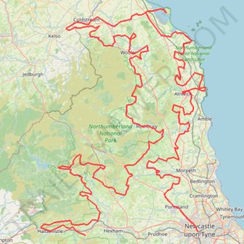
TET_UK-01-Borderlands_20250704
- Distance: 384.5 mi
- Elevation gain: 7,910 m
- Maximum elevation: 365 m
- Elevation loss: 7,788 m
- Minimum elevation: 0 m
Interactive trail map
Make a donation
Gear up for your next adventure:
As an Amazon Associate, this site earns from qualifying purchases at no extra cost to you.
Trail profile
- Distance: 384.5 mi
- Elevation gain: 7,910 m
- Maximum elevation: 365 m
- Elevation loss: 7,788 m
- Minimum elevation: 0 m
Make a donation
Gear up for your next adventure:
As an Amazon Associate, this site earns from qualifying purchases at no extra cost to you.
About this trail
Name: TET_UK-01-Borderlands_20250704 trail, distance, elevation, map, profile, GPS track
Coordinates: 54.95761 -2.52029 55.68369 -1.57883
Topography: Newcastle upon Tyne topographic map, elevation, terrain
Make a donation
Gear up for your next adventure:
As an Amazon Associate, this site earns from qualifying purchases at no extra cost to you.
Other hiking, mountain biking, running and outdoor activity trails
Click on a trail to view its statistics, map and profile.
Hungry Law Loop From Parking
United Kingdom > Scotland > Scottish Borders
Distance: 11.9 mi • Elevation gain: 495 m • Maximum elevation: 496 m
River Teviot Bike Loop from Jedburgh
United Kingdom > Scotland > Scottish Borders > Jedburgh
Distance: 9.4 mi • Elevation gain: 130 m • Maximum elevation: 93 m
Leamington and Walbottle circular
United Kingdom > England > Tyne and Wear > Newcastle upon Tyne > Blucher
Distance: 2.1 mi • Elevation gain: 72 m • Maximum elevation: 90 m
Make a donation
Gear up for your next adventure:
As an Amazon Associate, this site earns from qualifying purchases at no extra cost to you.
Carlisle Running
United Kingdom > England > Cumberland > Carlisle
Rat race the wall 2024
Distance: 69.8 mi • Elevation gain: 1,342 m • Maximum elevation: 332 m
Housesteads Link
United Kingdom > England > Northumberland > Hexham
Connecting walk between Hadrian's Wall Path and the car park at Housesteads
Distance: 0.4 mi • Elevation gain: 11 m • Maximum elevation: 252 m
Beadnell beach
United Kingdom > England > Northumberland > Beadnell > Benthall
Morning walk
Distance: 0.5 mi • Elevation gain: 8 m • Maximum elevation: 8 m