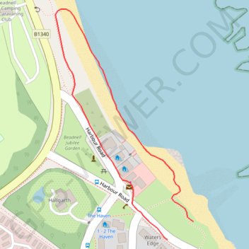
Thank you for supporting this site ❤️
Make a donation
Make a donation
Gear up for your next adventure:
As an Amazon Associate, this site earns from qualifying purchases at no extra cost to you.
Beadnell beach
Morning walk
- Distance: 0.5 mi
- Elevation gain: 8 m
- Maximum elevation: 8 m
- Elevation loss: 5 m
- Minimum elevation: 0 m
- Moving time: 17 m 11 s
- Moving speed: 1.7 mph
- Maximum speed: 3.9 mph
- Total time: 18 m 25 s
- Global speed: 1.6 mph
Interactive trail map
Thank you for supporting this site ❤️
Make a donation
Make a donation
Gear up for your next adventure:
As an Amazon Associate, this site earns from qualifying purchases at no extra cost to you.
Trail profile
- Distance: 0.5 mi
- Elevation gain: 8 m
- Maximum elevation: 8 m
- Elevation loss: 5 m
- Minimum elevation: 0 m
- Moving time: 17 m 11 s
- Moving speed: 1.7 mph
- Maximum speed: 3.9 mph
- Total time: 18 m 25 s
- Global speed: 1.6 mph
Thank you for supporting this site ❤️
Make a donation
Make a donation
Gear up for your next adventure:
As an Amazon Associate, this site earns from qualifying purchases at no extra cost to you.
About this trail
Name: Beadnell beach trail, distance, elevation, map, profile, GPS track
Coordinates: 55.55813 -1.63484 55.56115 -1.63164
Topography: Northumberland topographic map, elevation, terrain
Thank you for supporting this site ❤️
Make a donation
Make a donation
Gear up for your next adventure:
As an Amazon Associate, this site earns from qualifying purchases at no extra cost to you.