Make a donation
Gear up for your next adventure:
As an Amazon Associate, this site earns from qualifying purchases at no extra cost to you.
South Canterbury
Interactive trail map
Make a donation
Gear up for your next adventure:
As an Amazon Associate, this site earns from qualifying purchases at no extra cost to you.
Trail profile
- Distance: 72.0 mi
- Elevation gain: 312 m
- Maximum elevation: 61 m
- Elevation loss: 307 m
- Minimum elevation: 3 m
Make a donation
Gear up for your next adventure:
As an Amazon Associate, this site earns from qualifying purchases at no extra cost to you.
About this trail
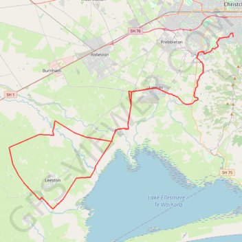
Name: South Canterbury trail, distance, elevation, map, profile, GPS track
Coordinates: -43.79744 172.22231 -43.56907 172.62470
Make a donation
Gear up for your next adventure:
As an Amazon Associate, this site earns from qualifying purchases at no extra cost to you.
Other hiking, mountain biking, running and outdoor activity trails
Click on a trail to view its statistics, map and profile.
Birdlings Flat Gravel/Unpaved Cycling
New Zealand > Canterbury > Christchurch City > Banks Peninsula Community
Distance: 13.3 mi • Elevation gain: 111 m • Maximum elevation: 38 m
Halswell River
New Zealand > Canterbury > Christchurch City > Banks Peninsula Community
Distance: 42.8 mi • Elevation gain: 320 m • Maximum elevation: 40 m