Thank you for supporting this site ❤️
Make a donation
Make a donation
Gear up for your next adventure:
As an Amazon Associate, this site earns from qualifying purchases at no extra cost to you.
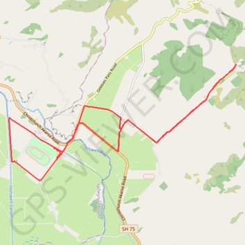
Birdlings Flat Gravel/Unpaved Cycling
- Distance: 13.3 mi
- Elevation gain: 111 m
- Maximum elevation: 38 m
- Elevation loss: 112 m
- Minimum elevation: 1 m
- Moving time: 1 h 10 s
- Moving speed: 13.3 mph
- Maximum speed: 18.3 mph
- Total time: 1 h 10 s
- Global speed: 13.3 mph
Interactive trail map
Thank you for supporting this site ❤️
Make a donation
Make a donation
Gear up for your next adventure:
As an Amazon Associate, this site earns from qualifying purchases at no extra cost to you.
Trail profile
- Distance: 13.3 mi
- Elevation gain: 111 m
- Maximum elevation: 38 m
- Elevation loss: 112 m
- Minimum elevation: 1 m
- Moving time: 1 h 10 s
- Moving speed: 13.3 mph
- Maximum speed: 18.3 mph
- Total time: 1 h 10 s
- Global speed: 13.3 mph
Thank you for supporting this site ❤️
Make a donation
Make a donation
Gear up for your next adventure:
As an Amazon Associate, this site earns from qualifying purchases at no extra cost to you.
About this trail
Name: Birdlings Flat Gravel/Unpaved Cycling trail, distance, elevation, map, profile, GPS track
Coordinates: -43.73734 172.57135 -43.70717 172.65251
Thank you for supporting this site ❤️
Make a donation
Make a donation
Gear up for your next adventure:
As an Amazon Associate, this site earns from qualifying purchases at no extra cost to you.
Other hiking, mountain biking, running and outdoor activity trails
Click on a trail to view its statistics, map and profile.
Halswell River
New Zealand > Canterbury > Christchurch City > Banks Peninsula Community
Distance: 42.8 mi • Elevation gain: 320 m • Maximum elevation: 40 m