Cape Byron
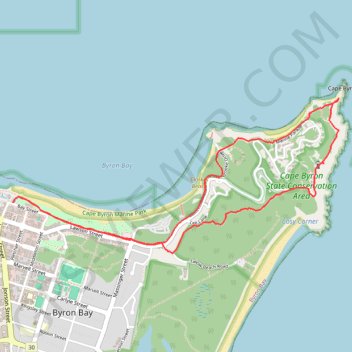
Interactive trail map
Trail profile
- Distance: 4.2 mi
- Elevation gain: 186 m
- Maximum elevation: 78 m
- Elevation loss: 186 m
- Minimum elevation: 0 m
About this trail
Name: Cape Byron trail, distance, elevation, map, profile, GPS track
Start: Bay Street, Byron Bay, Byron Shire Council, New South Wales, 2481, Australia (-28.64109 153.61329)
End: Bay Street, Byron Bay, Byron Shire Council, New South Wales, 2481, Australia (-28.64109 153.61333)
Coordinates: -28.64447 153.61329 -28.63417 153.63791
Other hiking, mountain biking, running and outdoor activity trails
Click on a trail to view its statistics, map and profile.