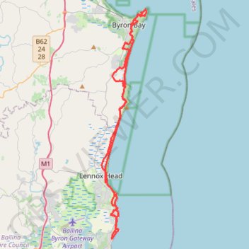
Import a GPX file

Byron Bay - Ballina

#MTB #Loop

  • Distance: 40.8 mi
  • Elevation gain: 865 m
  • Maximum elevation: 89 m
  • Elevation loss: 865 m
  • Minimum elevation: -1 m

Interactive trail map

Trail profile

  • Distance: 40.8 mi
  • Elevation gain: 865 m
  • Maximum elevation: 89 m
  • Elevation loss: 865 m
  • Minimum elevation: -1 m

About this trail

Other hiking, mountain biking, running and outdoor activity trails

Click on a trail to view its statistics, map and profile.

Byron Bay Lighthouse Loop

Australia > New South Wales > Byron Bay

Cape Byron State Conservation Area. #Hiking #Loop #CapeByron

Distance: 2.4 mi • Elevation gain: 160 m • Maximum elevation: 77 m

Cape Byron

Australia > New South Wales > Byron Bay

Cape Byron State Conservation Area. #Hiking #Loop #CapeByron

Distance: 4.2 mi • Elevation gain: 186 m • Maximum elevation: 78 m

Gear up for your next adventure:

🗺️Ordnance Survey Maps - Essential paper maps for hiking across the UK national parks
👖Convertible Hiking Trousers - Versatile zip-off pants for changing mountain weather conditions
🥾Men's Waterproof Hiking Boots - Durable footwear with deep lugs for muddy and rocky UK terrains
🧤Waterproof Overmitts - Extreme weather protection for hikers and mountaineers
🧣Neck Gaiters - Protects against wind and sun on exposed ridges and peaks

As an Amazon Associate, this site earns from qualifying purchases at no extra cost to you.