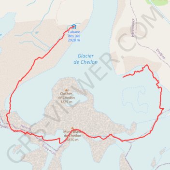
Mont Blanc de Cheilon
- Distance: 5.6 mi
- Elevation gain: 978 m
- Maximum elevation: 3,847 m
- Elevation loss: 1,027 m
- Minimum elevation: 2,907 m
Interactive trail map
Trail profile
- Distance: 5.6 mi
- Elevation gain: 978 m
- Maximum elevation: 3,847 m
- Elevation loss: 1,027 m
- Minimum elevation: 2,907 m
About this trail
Name: Mont Blanc de Cheilon trail, distance, elevation, map, profile, GPS track
Start: Hérémence, Hérens, Wallis, 1987, Switzerland (46.00232 7.42989)
End: Cabane des Dix, Pas du Chat, Hérémence, Hérens, Wallis, 1987, Switzerland (46.01110 7.41781)
Coordinates: 45.99083 7.40084 46.01110 7.43999
Other hiking, mountain biking, running and outdoor activity trails
Click on a trail to view its statistics, map and profile.
PT23DS2 Lörrach → Cadaqués
Germany > Baden-Württemberg > Landkreis Lörrach > Lörrach (Kernstadt)
Distance: 652.9 mi • Elevation gain: 13,130 m • Maximum elevation: 1,505 m