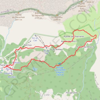
Tour des Ayères Plaine Joux
- Distance: 5.2 mi
- Elevation gain: 395 m
- Maximum elevation: 1,641 m
- Elevation loss: 397 m
- Minimum elevation: 1,343 m
Interactive trail map
Trail profile
- Distance: 5.2 mi
- Elevation gain: 395 m
- Maximum elevation: 1,641 m
- Elevation loss: 397 m
- Minimum elevation: 1,343 m
About this trail
Name: Tour des Ayères Plaine Joux trail, distance, elevation, map, profile, GPS track
Coordinates: 45.94960 6.74022 45.96140 6.77884
Other hiking, mountain biking, running and outdoor activity trails
Click on a trail to view its statistics, map and profile.
Ultra-Trail du Mont Blanc (UTMB)
France > Auvergne-Rhône-Alpes > Upper Savoy > Chamonix-Mont-Blanc
Distance: 104.2 mi • Elevation gain: 10,450 m • Maximum elevation: 2,535 m
UTMB 2020
France > Auvergne-Rhône-Alpes > Upper Savoy > Chamonix-Mont-Blanc > Les Bossons
Total: 171.3km
Distance: 104.5 mi • Elevation gain: 10,526 m • Maximum elevation: 2,574 m
TTdMB-1 Tour Du Mont Blanc - Itinéraire Principal
France > Auvergne-Rhône-Alpes > Upper Savoy > Chamonix-Mont-Blanc
Distance: 103.1 mi • Elevation gain: 10,535 m • Maximum elevation: 2,537 m
PT23DS2 Lörrach → Cadaqués
Germany > Baden-Württemberg > Landkreis Lörrach > Lörrach (Kernstadt)
Distance: 652.9 mi • Elevation gain: 13,130 m • Maximum elevation: 1,505 m