Make a donation
Gear up for your next adventure:
As an Amazon Associate, this site earns from qualifying purchases at no extra cost to you.
Anstey Hill Recreation Park
Interactive trail map
Make a donation
Gear up for your next adventure:
As an Amazon Associate, this site earns from qualifying purchases at no extra cost to you.
Trail profile
- Distance: 3.4 mi
- Elevation gain: 189 m
- Maximum elevation: 388 m
- Elevation loss: 189 m
- Minimum elevation: 228 m
- Moving time: 1 h 10 m
- Moving speed: 2.9 mph
- Maximum speed: 4.4 mph
- Total time: 1 h 12 m
- Global speed: 2.8 mph
Make a donation
Gear up for your next adventure:
As an Amazon Associate, this site earns from qualifying purchases at no extra cost to you.
About this trail
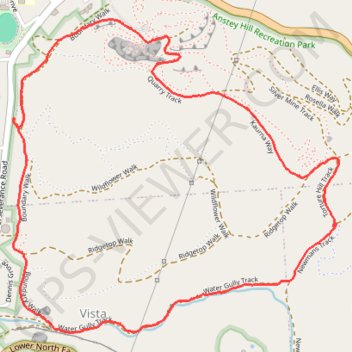
Name: Anstey Hill Recreation Park trail, distance, elevation, map, profile, GPS track
Coordinates: -34.83664 138.72692 -34.82380 138.74316
Make a donation
Gear up for your next adventure:
As an Amazon Associate, this site earns from qualifying purchases at no extra cost to you.
Other hiking, mountain biking, running and outdoor activity trails
Click on a trail to view its statistics, map and profile.
Loop walk via Virgin Valley, Silver Mine Track, DeVeg and Living on the quarry edge in Anstey Hill Recreation Park
Australia > South Australia > Adelaide
Distance: 2.1 mi • Elevation gain: 119 m • Maximum elevation: 383 m
Dry Creek to the Triangle
Australia > South Australia > Adelaide
Distance: 13.2 mi • Elevation gain: 174 m • Maximum elevation: 204 m
Dry Creek Trail
Australia > South Australia > Adelaide
Distance: 14.0 mi • Elevation gain: 263 m • Maximum elevation: 204 m