Thank you for supporting this site ❤️
Make a donation
Make a donation
Gear up for your next adventure:
As an Amazon Associate, this site earns from qualifying purchases at no extra cost to you.
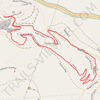
Loop walk via Virgin Valley, Silver Mine Track, DeVeg and Living on the quarry edge in Anstey Hill Recreation Park
- Distance: 2.1 mi
- Elevation gain: 119 m
- Maximum elevation: 383 m
- Elevation loss: 120 m
- Minimum elevation: 270 m
- Moving time: 48 m 27 s
- Moving speed: 2.7 mph
- Maximum speed: 4.4 mph
- Total time: 49 m 2 s
- Global speed: 2.6 mph
Interactive trail map
Thank you for supporting this site ❤️
Make a donation
Make a donation
Gear up for your next adventure:
As an Amazon Associate, this site earns from qualifying purchases at no extra cost to you.
Trail profile
- Distance: 2.1 mi
- Elevation gain: 119 m
- Maximum elevation: 383 m
- Elevation loss: 120 m
- Minimum elevation: 270 m
- Moving time: 48 m 27 s
- Moving speed: 2.7 mph
- Maximum speed: 4.4 mph
- Total time: 49 m 2 s
- Global speed: 2.6 mph
Thank you for supporting this site ❤️
Make a donation
Make a donation
Gear up for your next adventure:
As an Amazon Associate, this site earns from qualifying purchases at no extra cost to you.
About this trail
Name: Loop walk via Virgin Valley, Silver Mine Track, DeVeg and Living on the quarry edge in Anstey Hill Recreation Park trail, distance, elevation, map, profile, GPS track
Coordinates: -34.82985 138.73358 -34.82438 138.74265
Thank you for supporting this site ❤️
Make a donation
Make a donation
Gear up for your next adventure:
As an Amazon Associate, this site earns from qualifying purchases at no extra cost to you.
Other hiking, mountain biking, running and outdoor activity trails
Click on a trail to view its statistics, map and profile.